Live Camera: SR-1 : South of Mar Monte Ave
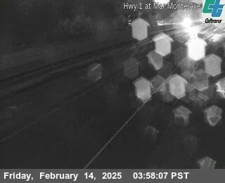
SR-1 : South of Mar Monte Ave is a live webcam in California, USA, streaming in real time.
- Location
- California, USA
- Status
- Live now
- Time zone
- America/Los_Angeles
- Category
- Traffic
- Coordinates
- 36.9459, -121.8458
Watsonville Traffic View on SR-1
The SR-1: south of Mar Monte Ave webcam provides a perspective of daily traffic patterns in Watsonville, California. This live cam allows one to avoid guessing road conditions, the flow of traffic, and the atmospheric conditions in the area. On Volve Vision, it complies with a travel-oriented search and also benefits the residents with a useful view of one of the corridors that is busiest in the city.
Rather than acting as scenery alone, this SR-1 live cam shows a working part of town where vehicles, timing, and traffic flow matter. That makes it useful for drivers planning an approach, residents checking the road, and visitors who want to understand how the city moves. It is a simple camera, but that simplicity is what gives it value.
Why this camera is useful
Watsonville is closely connected to regional travel and local infrastructure, so a road view like this has everyday value. The camera helps users judge activity on the route and get a feel for the pace of the area at different times. Volve Vision presents it as a dependable reference point for anyone who prefers seeing conditions before heading out.
Given that the feed is focused on a central road segment, it can be important to the commuters, delivery drivers, and travelers moving through California’s central coast corridor. Additionally, it serves those perusing a live webcam catalog who prefer something more utilitarian than picturesque. The shot captures a real, dynamic location, which tends to be the most practical type of webcam.
Places to know in Watsonville
Watsonville City Plaza is a recognizable gathering point and a useful landmark for understanding the local center. It often appears in searches for the city’s main public space, along with nearby shops and services that support daily life. For visitors, it gives a simple starting point for exploring downtown Watsonville and the surrounding streets.
Watsonville Wetlands are a well-known natural area linked to the city and the wider coastal environment. Visitors often look for this place when they want to pair an urban stop with outdoor scenery. It adds contrast to the road-focused view of the SR-1 webcam by showing that the area is also connected to open landscapes.
Ramsay Park is one of the city’s familiar local spaces, often recognized by families and casual visitors. It gives Watsonville a community side that balances the practical character seen on the camera. For anyone researching the city, it is one of the names that helps shape a fuller picture of local life beyond the highway corridor.
Downtown Watsonville is where many visitors look for the city’s everyday pulse, with civic functions, businesses, and public activity concentrated in a compact area. It is a natural point of reference for users who discover the camera and want to place the road view within the broader city layout. The downtown setting helps explain the importance of this route.
Pajaro Valley is strongly connected to Watsonville and often associated with the region’s agricultural and transportation identity. People searching for the city frequently encounter this name as part of the local geography. It gives context to the live cam by showing that the road is part of a wider valley community with steady movement and practical importance.
California and wider travel context
For travelers passing through California, Watsonville is within a state full of prominent attractions, making even an ordinary road cam part of a larger journey. Highlights like San Francisco, Los Angeles, San Diego, Yosemite National Park, and Lake Tahoe exemplify the diverse range of experiences in the state’s urban and natural getaways. A road cam provides the daily routine that links those points of interest.
That broader context is one reason users continue to revisit live webcam pages on Volve Vision. A highway or street view is just as informative as a landmark view because it shows how local areas operate between the place viewed and the destination. For those journeying across California, this SR-1 live cam provides a sense of the road to add to what a map shows.
What viewers gain from the feed
The biggest asset of the camera is clarity. They can see a live section of the SR-1 and get a glimpse of traffic conditions and the levels of activity as well as the built environment. This is greatly beneficial for people determining what time to leave, how to plan a detour, or what to anticipate on coming to Watsonville. Additionally, it adds relevance to the page for road cam users, making it road cam users.
Short summary
More live cameras nearby
- Live HD Webcam Old Courthouse Square, Santa Rosa, CA, USA
- Live HD Webcam of Monterey Bay Aquarium Ocean View, CA
- Shark, Monterey Bay Aquarium, California, USA
- Live Webcam Snow Summit Big Bear Lake, California, USA
- Live Big Bear Bald Eagle Nest Webcam, Fawnskin, CA, USA
- Big Bear Lake, CA, USA Live Snow Summit Slopeside Webcam


World map
Explore live cameras from around the world
Open the global map, jump between countries and cities, and discover new live views beyond this page.
Open camera mapComments
Share your thoughts, ask a question, or continue the discussion inside a thread.
Join the discussion to leave a comment or reply inside a thread.
Frequently asked questions
Where can I watch the SR-1 : South of Mar Monte Ave live cam?
Is there a live webcam of SR-1 : South of Mar Monte Ave?
How do I watch SR-1 : South of Mar Monte Ave webcam live?
What does the SR-1 : South of Mar Monte Ave camera show?
Is there a webcam in California, USA?
Is the SR-1 : South of Mar Monte Ave webcam free to watch?